


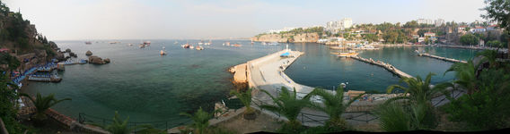


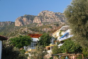
One of our planning sources, a German website by Peter Lill, suggested Özmen Pansiyon as a place to stay in Antalya, which turned out to be a good choice as it is good value, located in the old town, and has a large rooftop terrace with view of the sea. To my knowledge, the old town (plus maybe the Düden Waterfalls) is the only place in Antalya worth visiting as a tourist.
| Coast from above | | | | |
|---|---|---|---|---|
| | | | |
| Old Town | | | | |
| | | | |
| | | | |
| Harbor | | | ||
| | | ||
| | |||
| | | | |
| Özmen Pansiyon | | | | |
| Center | | | | |
Getting from Antalya to Kaş (ancient Antiphellos) by bus is a picturesque four-hours ride. We were lucky to be there on Friday, when the local market is held. We chose to stay in Aphrodite Pansiyon, because it offers a good view of the village and the surrounding bay, in particular at sunset. The family owning and running it turned out to be extremely friendly.
| First impression |  |  | 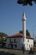 |  |
|---|---|---|---|---|
| Flats in the north |  |  |  |  |
| Friday market |  |  |  |  |
 |  |  |  | |
| Center |  |  |  |  |
 |  |  |  | |
 |  |  |  | |
 |  | |||
 |  | |||
| Harbor |  |  |  |  |
 |  |  |  | |
 | ||||
| Mosque |  |  |  |  |
| Aphrodite Pansiyon |  |  |  |  |
 |  |  |  | |
 |  |  |  | |
 |  |  |  | |
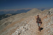
We knew that our first stage of the Lycian Way would be pretty tough.
Yet we did not expect that it was that lengthy, rugged, and hot.
We brought about 4 liters of water, but in total needed 8 liters.
Departing from Kaş at 6:10, we arrived in Aperlaı as late as 22:15,
gladly using our headlamps, after running out of water four hours before.
We cannot recommend the last third of our track (which is not part of the official Lycian Way anyway)
because it takes very long time and after the gorge the markers are only partially visible.
For the first two thirds of our way, we followed the official path, which is well marked.
We got a very friendly unexpected breakfast from a fisher/farmer family at Fakdere Mevki.
Arriving at a junction marked "turnoff" below, we continued straight
(because, according to the map, this should have been a shortcut)
and pretty soon hit a gorge at a place marked Barak Limanı on Open Street Map (OSM) or Open Cycle Map (OCM).
The gorge was a perfect place to have siesta as it was relatively cool.
After climbing out of the gorge, we tried hard hooking up with a path that is marked on OSM/OCM,
but this turned out pretty wrong. I meanwhile removed the wrong section on the map (using Potlatch 2).
We fought ourselves for about an hour through thorny shrubs
until we finally hit a marked trail, which we were able to follow more or less until Aperlaı.
So we managed to do accomplish our planned stage, but at quite some loss:
we not only received numerous scratches on our legs and arms,
but I also got a very bad blister that prohibited further trekking on my part.
Moreover, I ruined Gabor's hiking poles and lost my 165€ pocket camera
somewhere in the bushes during the first hour after the gorge :-(
During the whole day we were faithfully escorted by two dogs.
On the photos you can see how exhausted they were, being 16 hours in the heat
with essentially no food and only very sparse freshwater.
We did not even take photos after the gorge because there was not much to see except shrubs
and we were struggling with more essential issues.
A GPS recording of our hiking route is available for download as GPX file or
KML file for Google Earth.
It can be directly viewed on Google Terrain Maps (including waypoints) and on GPSies (including waypoints and statistics).
| Kaş-Fakdere Mevki |  |  |  |  |
|---|---|---|---|---|
 |  |  |  | |
 |  |  |  | |
 |  | |||
 |  |  |  | |
| Fakdere Mevki |  |  |  |  |
 |  |  |  | |
| Fakdere Mevki-Barak Limanı |  |  |  |  |
 |  |  |  | |
 |  |  |  | |
 |  |  |  | |
We were extremely glad to arrive at Aperlaı, where we had booked a room at the only Purple House, the only place to stay there. The owner and his staff received us very friendly and did all they could to help us to recover from the long hike and feel at home. He also arranged a boat for us to go to Kekova to swim and see the partly sunken ruins of Dolchiste/Dolikisthe on its northern shore, then continue to Üçağız via Kaleköy (or just "Kale", ancient Simena) with its Genoese castle and its ancient Lycian sarcophagi.
| Purple House at Aperlaı |  |  |  |  |
|---|---|---|---|---|
 |  |  |  | |
| Boat trip to Kekova |  |  |  |  |
 |  |  |  | |
 |  |  |  | |
 |  |  |  | |
 |  |  |  | |
| Sunken City (Lost City) |  |  |  |  |
 |  |  |  | |
| Kaleköy |  |  |  |  |
 |  |  |  | |
 |  |  |  | |
 |  |  |  | |
 |  |  |  | |
 |  |  |  | |
 |  |  |  |
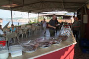
I ended up staying in the charming fishing village of Üçağız (ancient Teimioussa) for four days —
much longer than expected, in order to give my blister more time to heal.
This relaxed place certainly was not the worst one to be.
At Ibrahim Restaurant we got into contact with the very hospitable owners of
Baba Veli Pansiyon,
which offered excellent value and the quietness that I was looking for,
perfectly located directly at the sea shore just a few steps from the central waterfront.
On the second day we accepted a pretty irresistible offer for a full-day boat trip,
although this included Kekova, Sunken City, and Kaleköy, which we had already seen.
Gabor left the next morning to continue the itinerary we had planned, while I spent
two more relaxing days in the village
| arrival |  |  |  |  | ||||||||||||||||||||||||||||||||||||||||||||||||||||||||||||||||||||||||||||||||||||||||||||||||||||||||||||||||||||||||||||||||||||||||||||||||||||||||||
|---|---|---|---|---|---|---|---|---|---|---|---|---|---|---|---|---|---|---|---|---|---|---|---|---|---|---|---|---|---|---|---|---|---|---|---|---|---|---|---|---|---|---|---|---|---|---|---|---|---|---|---|---|---|---|---|---|---|---|---|---|---|---|---|---|---|---|---|---|---|---|---|---|---|---|---|---|---|---|---|---|---|---|---|---|---|---|---|---|---|---|---|---|---|---|---|---|---|---|---|---|---|---|---|---|---|---|---|---|---|---|---|---|---|---|---|---|---|---|---|---|---|---|---|---|---|---|---|---|---|---|---|---|---|---|---|---|---|---|---|---|---|---|---|---|---|---|---|---|---|---|---|---|---|---|---|---|---|---|
 |  |  |  | |||||||||||||||||||||||||||||||||||||||||||||||||||||||||||||||||||||||||||||||||||||||||||||||||||||||||||||||||||||||||||||||||||||||||||||||||||||||||||
 |  |  |  | |||||||||||||||||||||||||||||||||||||||||||||||||||||||||||||||||||||||||||||||||||||||||||||||||||||||||||||||||||||||||||||||||||||||||||||||||||||||||||
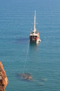
| bathing boat |  |  |  | 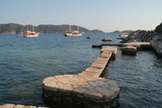 | ||||||||||||||||||||||||||||||||||||||||||||||||||||||||||||||||||||||||||||||||||||||||||||||||||||||||||||||||||||||||||||||||||||||||||||||||||||||||||
 | ||||||||||||||||||||||||||||||||||||||||||||||||||||||||||||||||||||||||||||||||||||||||||||||||||||||||||||||||||||||||||||||||||||||||||||||||||||||||||||||
 |  |  |  | |||||||||||||||||||||||||||||||||||||||||||||||||||||||||||||||||||||||||||||||||||||||||||||||||||||||||||||||||||||||||||||||||||||||||||||||||||||||||||
 |  |  |  | |||||||||||||||||||||||||||||||||||||||||||||||||||||||||||||||||||||||||||||||||||||||||||||||||||||||||||||||||||||||||||||||||||||||||||||||||||||||||||
 |  |  |  | |||||||||||||||||||||||||||||||||||||||||||||||||||||||||||||||||||||||||||||||||||||||||||||||||||||||||||||||||||||||||||||||||||||||||||||||||||||||||||
| morning mood | 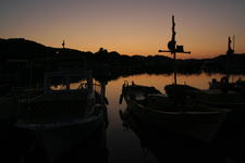 |  |  |  | ||||||||||||||||||||||||||||||||||||||||||||||||||||||||||||||||||||||||||||||||||||||||||||||||||||||||||||||||||||||||||||||||||||||||||||||||||||||||||
 | ||||||||||||||||||||||||||||||||||||||||||||||||||||||||||||||||||||||||||||||||||||||||||||||||||||||||||||||||||||||||||||||||||||||||||||||||||||||||||||||
 | ||||||||||||||||||||||||||||||||||||||||||||||||||||||||||||||||||||||||||||||||||||||||||||||||||||||||||||||||||||||||||||||||||||||||||||||||||||||||||||||
 |  |  |  | |||||||||||||||||||||||||||||||||||||||||||||||||||||||||||||||||||||||||||||||||||||||||||||||||||||||||||||||||||||||||||||||||||||||||||||||||||||||||||
 |  |  |  | |||||||||||||||||||||||||||||||||||||||||||||||||||||||||||||||||||||||||||||||||||||||||||||||||||||||||||||||||||||||||||||||||||||||||||||||||||||||||||
 | |  |  | |||||||||||||||||||||||||||||||||||||||||||||||||||||||||||||||||||||||||||||||||||||||||||||||||||||||||||||||||||||||||||||||||||||||||||||||||||||||||||
| Babaveli Pansiyon |  |  | 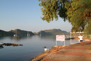 |  | ||||||||||||||||||||||||||||||||||||||||||||||||||||||||||||||||||||||||||||||||||||||||||||||||||||||||||||||||||||||||||||||||||||||||||||||||||||||||||
 |  |  |  | |||||||||||||||||||||||||||||||||||||||||||||||||||||||||||||||||||||||||||||||||||||||||||||||||||||||||||||||||||||||||||||||||||||||||||||||||||||||||||
 |  |  |  the blister, disinfected using Bromine | |||||||||||||||||||||||||||||||||||||||||||||||||||||||||||||||||||||||||||||||||||||||||||||||||||||||||||||||||||||||||||||||||||||||||||||||||||||||||||
| misc |  |  Ibrahim and Hassan restaurants
| 2nd excursion: bathing
| 2nd excursion: Kekova and Sunken City
| 2nd excursion: Kaleköy
|
| 2nd excursion: return
| evening mood
| | |||||||||||||||||||||||||||||||||||||||||||||||||||||||||||||||||||||||||||||||||||||||||||||||||||||||||||||||||||||||||||||||||||||||||||||||||||||
Eventually I had to leave cosy and relaxed Üçağız to catch up with Gabor,
who had left two days before to see Myra
and hike one of the most beautiful stretches of the Lycian Way: around the Cape south of Çavuşköy.
I took the only public transport to/from the village: a minibus leaving daily at 8 AM.
Since the dolmuş is notoriously overloaded,
like two more passengers I was offered a plastic chair in the aile, which was not the safest, but fun.
When I arrived, I did not yet know at which place to stay and the choice is abundant,
but after praying and hiking the beach road to its northern end, I was attracted by the signpost of
Fire Pansiyon. This turned out to be a very good choice not only for me, but also for Gabor and
two Bavarians he had met on the way, as it is a very relaxed and inexpensive place with great food
and very conveniently located to visit the Yanartaş.
| arrival |  |  |  |  |
|---|---|---|---|---|
 |  |  |  | |
| Fire Pansiyon |  |  |  |  |
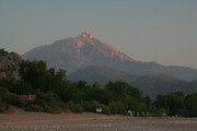
The Yanartaş consists of two flame fields (where the upper one is not worth visiting as it as much
less impressive and takes half an hour more of uphill hiking). The flames gave rise to the legend of
the Chimera monster,
but are in fact nurtured by natural gas constantly emerging from the ground. In contrast to what I read,
the flames are not self-igniting, which I tried out by blowing out a smaller flame - okay, and then re-igniting it manually ;-)
A GPS recording of our evening stroll is available for download as GPX file or
KML file for Google Earth.
It can be directly viewed on Google Terrain Maps (including waypoints), and on GPSies (including waypoints and statistics).
| Yanartaş: lower field |  |  |  |  |
|---|---|---|---|---|
 |  |  |  | |
 |  |  |  | |
 |  |  |  | |
 |  |  |  | |
 |  |  |  | |
 |  |  |  | |
| Yanartaş: upper field |  |  |  |  |
 |  |  |  | |
 |  |  |  | |
| moonrise |  |  |  |  |
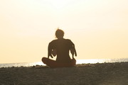
The close-by ancient town of Olympos appears to be a meeting place of Yoga fans. Though I'm not a friend of Yoga for its spiritual background, the sun dance (or whatever it is called) performed by a young German lady was very beautiful to watch.
| between Cıralı and Olympos | 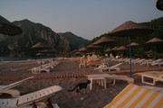 |  |  |  |
|---|---|---|---|---|
 |  |  |  | |
 |  |  |  | |
 |  |  |  | |
 |  |  |  | |
 |  | |||
| Yoga practitioners |  |  |  |  |
 |  |  |  | |
 |  |  |  | |
 |  |  |  | |
 |  |  |  | |
 |  |  |  | |
 |  |  |  | |
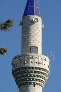
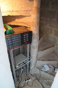
Towards the end of my morning stroll, I passed by the mosque and realized that the minaret door was not closed. Since nobody was around, I took the opportunity to climb the tower to use it as a viewpoint. I also was curious to look for evidence if still a muezzin goes there in person for the adhan (call to prayer), and actually found some pretty decent PA equipment. This convinced me that at least in Cıralı the adhan is not broadcast or automatically reproduced, e.g., using an MP3 player. By the way, during all of my travels to Turkey so far, I never noticed anyone who cared about the adhan, though unavoidable to be heard five times each day.
| village center |  |  |  |  |
|---|---|---|---|---|
 | ||||
 |  |  |  | |
 |  |  |  | |
 |  |  |  | |
| mosque |  |  |  |  |
 |  |  |  | |
 |  |  |  | |
 |  |  | ||
 |  |  |  | |
 |  |  |  | |
| plants |  |  |  |  |
 |  |  |  | |
| last morning |  |  |  |  |
 |  |  |  | |
 |  |  |  | |
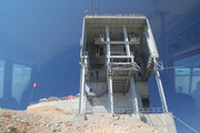
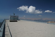
As the blister on my left foot was not yet sufficiently healed , Gabor climbed Mount Tahtalı (ancient Olympos) without me, while I took advantage of modern Austrian-Swiss technology in the form of a cableway (Turkish: teleferik) to get to the top as conveniently as most of the other tourists. Since the dolmuş driver had not picked me up from the pansiyon in Cıralı at the agreed time, I already feared that I would not make it in time to meet Gabor, but two young Turkish travelers from Istanbul were extremely helpful and took me with their car as far as to cableway station, such that I arrived at the top at 11 AM, just about an hour later than planned. Whereas clouds set in typically around noon, during that period visibility was still pretty good, while most of the tourists already left around noon.
| ride up |  |  |  |  |
|---|---|---|---|---|
 |  |  |  | |
 |  |  |  | |
 |  |  |  | |
| on the platform |  |  |  | |
 |  |  | ||
 |  |  |  | |
| Gabor arriving |  |  |  |  |
 |  | |||
 |  |  |  | |
 |  | |||
 |  |  |  | |
| on the upper deck |  |  |  |  |
 |  |  |  | |
 |  | |||
| paraglider leaving |  |  |  |  |
 | 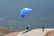 |  |  | |
 |  |  |  | |
| in the building |  |  |  |  |
 |  |  |  | |
| going down |  |  |  |  |
 |  |  |  | |
 |  |  |  | |
 |  |  |  | |
| gateway |  | 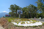 |  | 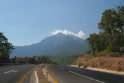 |
A GPS recording of this short hike is available for download as GPX file or
KML file for Google Earth.
It can be directly viewed on Google Terrain Maps (including waypoints), and on GPSies (including waypoints and statistics).
| North Harbor |  |  |  |  |
|---|---|---|---|---|
 |  | |||
| Phaselis |  |  | 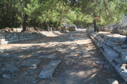 |  |
 |  | |||
| South Harbor |  |  |  |  |
 |  | |||
 |  | |||
A GPS recording of our afternoon hike is available for download as GPX file or
KML file for Google Earth.
It can be directly viewed on Google Terrain Maps (including waypoints), and on GPSies (including waypoints and statistics).
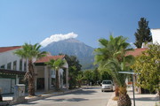
| north of the center |  |  |  |  |
|---|---|---|---|---|
| Hotel Jasmine |  |  |  |  |
 |  |  |  | |
 |  |  |  | |
| in the center |  |  |  |  |
 |  |  |  | |
 |  |  |  | |
 |  |  |  | |
| excursion to beach in the south |  |  |  |  |
 |  |  |  | |
 |  |  |  | |
 |  |  |  | |
 |  |  |  | |
 |  |  |  | |
 |  |  |  | |
| shops for Russian tourists |  |  |  |  |
 |  |  |  | |
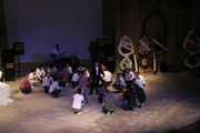
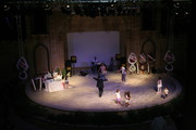
| a local wedding |  |  |  |  |
 |  |  |  | |
 |  |  |  | |
 |  |  |  | |
 |  |  |  | |
 |  |  |  | |
 |  |  |  | |
 |  |  |  |
| beach and Amsterdam Hotel |  |  |  |  |
|---|---|---|---|---|
| early morning in the center |  |  |  |  |
| bus ride to the airport |  |  |  |  |
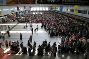
| at the airport |  |  |  |  |
|---|---|---|---|---|
 |  |  |  | |
 |  |  |  | |
| crossing Turkey |  |  |  |  |
| Istanbul and approach to Stuttgart |  |  |  |  |